Central Meteorological Observatory: Typhoon Du Surui will seriously affect Taiwan, Fujian and Guangdong.
Cctv newsAccording to the Central Meteorological Observatory, the No.5 typhoon "Du Surui" will move into the northeast of the South China Sea this year, and will land on the coast of Fujian and Guangdong in the morning of the 28th. The intensity of landing is strong typhoon (42-48m/s, 14-15), and it may go deep inland after landing, and its influence scope will be further expanded. "Du Surui" has the characteristics of strong landing intensity, strong wind and rain influence and wide range, and may be the strongest typhoon that landed in southern Fujian since 2017 and the strongest typhoon that affected eastern Guangdong in the past 10 years.
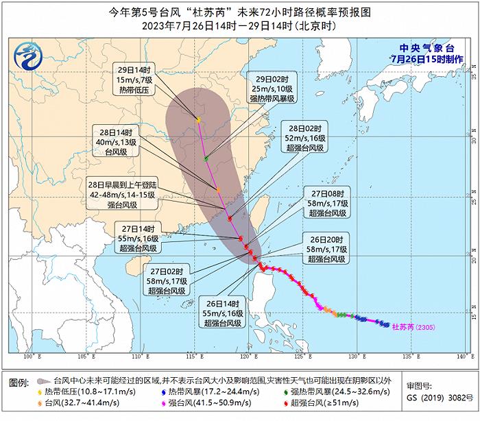
Typhoon "Du Surui" intensified into a super typhoon level on the evening of July 24th. At 14: 00 on the 26th, its center was located on the sea about 280 kilometers south of Eguanbi, Taiwan Province, China, and the maximum wind force near the center was 16 (55 m/s, super typhoon level).
It is estimated that Du Surui will move to the northwest at a speed of 10-15 kilometers per hour, with little change in intensity. It will move into the northeast of the South China Sea from the night of 26th to the morning of 27th, and land in Fuqing, Fujian to Huilai, Guangdong on the morning of 28th. It is likely to land in Jinjiang, Fujian to the border of Fujian and Guangdong (strong typhoon level, 42-48m/s, 14-15). After landing, it turned to the north, and the intensity gradually weakened, but the typhoon circulation will be maintained and northward for a long time. The Central Meteorological Observatory issued the first typhoon red warning this year at 10: 00 on the 26th.
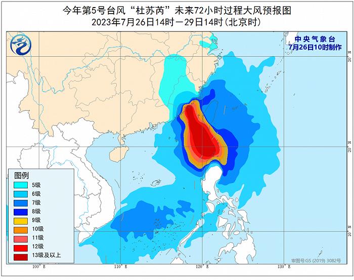
Gale forecast: It is predicted that from 26th to 29th, there will be 6-8 winds and 9-10 gusts in the east of Taiwan Province, eastern and southern South China Sea, bashi channel, Taiwan Province Strait, Taiwan Province Island and its coastal areas, south-central and eastern coastal areas of Fujian, eastern Guangdong, 9-12 winds and 13-15 gusts in the southern coastal areas of Fujian, bashi channel, northeastern South China Sea and south of Taiwan Province Strait, and the typhoon center will pass by.
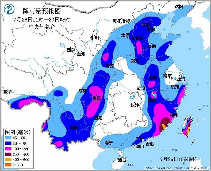
Rainfall forecast: It is estimated that from 26th to 29th, there will be heavy rains in parts of Taiwan Province Island, eastern Zhejiang, Fujian, eastern Guangdong and coastal areas, Jiangxi, Anhui, Huanghuai and North China, with heavy rains in eastern and southern Taiwan Province Island, central and southern Fujian and eastern coastal areas, eastern Zhejiang coastal areas and eastern Guangdong. Among them, the cumulative rainfall in the eastern and southern parts of Taiwan Province Island, south-central Fujian, eastern coastal areas of Zhejiang, eastern Guangdong and other places is 150 ~ 250 mm, local area is 300 ~ 500 mm, and local area in eastern Taiwan Province Island can reach 500 ~ 700 mm; The maximum hourly rainfall in the above areas is 30 ~ 60 mm, and the local rainfall can reach more than 80 mm.
Rainfall period: On 26th, the heavy rainfall mainly affected Taiwan Province Island and the coastal areas of Zhejiang, from 27th to 28th, it affected Zhejiang, Fujian, Guangdong and Jiangxi, and on 29th, it continued to affect Anhui, Huanghuai and North China.
In addition, from 26th to 28th, due to the typhoon’s long-distance influence, moderate to heavy rain will also occur in parts of the eastern part of southwest China, the eastern part of northwest China, North China, Huanghuai and other places, with local heavy rain to heavy rain.
It is estimated that from July 26th to 29th, there will be medium and high risk of typhoon disasters in southern Taiwan Province Island, Fujian, eastern Guangdong, southeastern Zhejiang and eastern Jiangxi. Among them, southern and northeastern Fujian, eastern Guangdong, southeastern Zhejiang and other places are prone to flash floods and geological disasters, and small and medium-sized rivers in southern Fujian and eastern Guangdong have meteorological risks of exceeding warning or exceeding guaranteed water levels; The southern part of Taiwan Province Island, the south-central and eastern parts of Fujian, the eastern part of Guangdong and some sea areas in the southeast of China are at risk of gale disaster.
Meteorologists have warned that "Du Surui" has a strong wind and rain intensity, which may cause serious disasters and bring large-scale rainfall to the inland north. The public in Taiwan Province, Fujian, Guangdong, Zhejiang, Jiangxi and other places need to do a good job in typhoon prevention. The public in Anhui, Huanghuai, North China, the eastern part of Southwest China and the eastern part of Northwest China should pay attention to prevent secondary disasters that may be caused by local heavy rainfall.